


By creating a reliable inventory of your assets, we give you a clear view of your currently owned property assets. Your users can use your current software on a desktop or mobile device to identify, track, locate, and analyse your physical assets to maximize productivity.
“Complex and unintegrated asset information management systems (AIMS) compound the information gaps, which make it difficult for staff to find the asset information they need to support decision-making. This means asset decisions depend heavily on the experience and judgement of individual staff without the benefit of objective data.”
Audited councils had high confidence in only 25 per cent of building assets, 20 per cent of drains, bridges and culverts and 18 per cent of recreation assets—such as sporting fields, playgrounds, and trees.
Project Scope
- Esri ArcGIS platform compatible
- High Accuracy
- Capture all attribute data
Aerial Drone Solutions were engaged to develop a custom solution so councils can manage their assets in every park. The key criteria for this project was;
1) Must have a high resolution orthomosaic;
2) Must have high accuracy using ground control points;
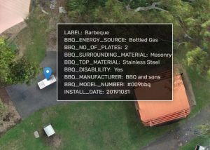
3) All attribute data within the parks must be entered (Bins, Bollards, Toilets, BBQ’s, etc)
4) Attribute data to be captured are Asset Number, Asset Description, Manufacturer, Items Description, Year Installed, Year to be Replaced, Unit Cost, Construction Material, Location;
5) All data needs to be imported into councils Esri ArcGIS platform.
“Audited councils had high confidence in only 25 per cent of building assets, 20 per cent of drains, bridges and culverts.``
Our solution enabled councils to have;
Increased governance – Increased visibility also lends itself to more effective governance. By knowing exact locations and attributes of their assets councils have a better handle on key assets.
Faster lead time to fix issues – Knowing exactly where and what your asset is assists our clients in rectifying issue more efficiently and cost effectively.
Asset Identification – As an example, anyone one with access could walk into a park and find the exact BBQ that needs replacing, or what foot bridge needs to be fixed without looking at a spreadsheet and trying to figure out which asset ID is where.
